Floodplain management is a shared responsibility that helps reduce risk and protect people, property and infrastructure. The City works within guidelines provided by the Government of Saskatchewan who adapts floodplain management and considers new scientific insights, shifting climate patterns and changing land use priorities. In Regina, the City manages development in and around waterways in accordance with provincial direction and regulations, working to ensure safe and sustainable land use in flood-prone areas.
What Is A Floodplain?
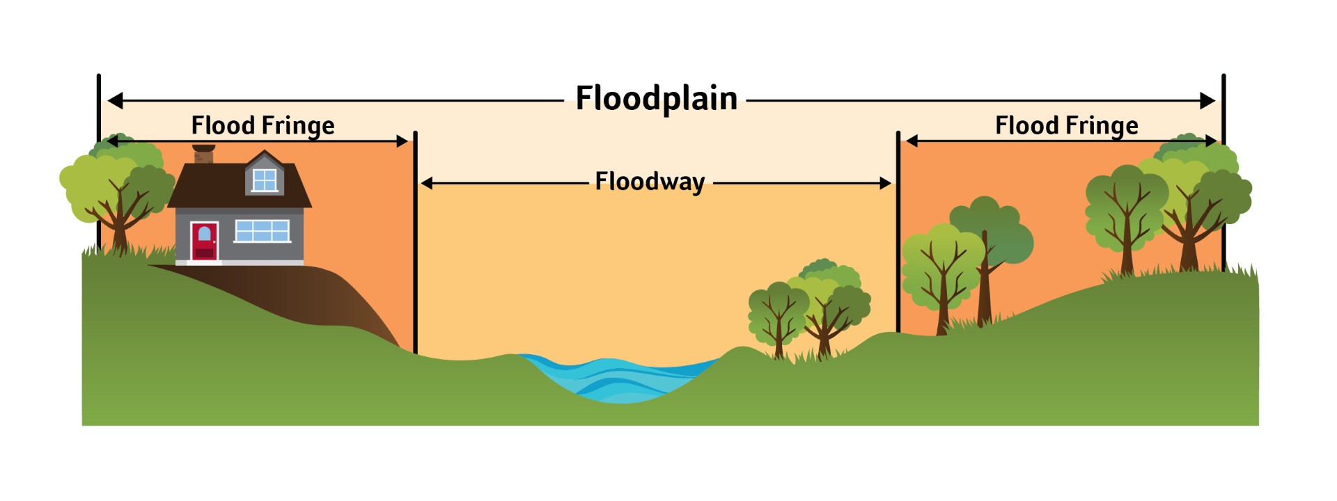
A floodpain is the area adjacent to a body of water that is most prone to flooding. Two main areas make up the floodplain:
- The floodway where water flows rapidly during flooding;
- The flood fringe where water flows more slowly.
 Figure 1: This figure shows what makes a floodplain.
How Is A Floodplain Identified?
The Water Security Agency (WSA) identifies the floodplain in Regina. The WSA, a provincial Crown corporation, maps the areas in the city located within the floodplain. Areas around Wascana Creek, Chuka Creek, Pilot Butte Creek, the south storm channel and the north storm channel form floodplains in Regina.
The City has implemented a combination of temporary and permanent flood mitigation measures to reduce the impacts of erosion, surface runoff and high water levels. These include engineered barriers and infrastructure designed to manage and reduce flood risk.
Are You On The Floodway?
To assess your risks, consider using flood maps and following the City of Regina’s Zoning Bylaw. Knowing if you are affected by floodways can help you stay safe and advocate for smarter flood management.
Flood Maps
Flood maps help to identify areas that may be at risk of flooding and are critical tools for informing communities about their flood risk.
Reference the City of Regina Floodplain Map to find out if your property is on the floodplain.
Building and Development in the Floodplain
The floodplain zone establishes different rules and regulations around development. The Government of Saskatchewan requires municipalities to restrict construction within the floodplain.
The City of Regina’s Zoning Bylaw includes information for new building and development regulations within the floodplain. New construction is not permitted within the floodway. Increased restrictions and flood-proofing measures are required for development within the flood fringe.
Over the past several years, the Water Security Agency (WSA) has been reviewing updates to flood maps across the province with improved flood map modeling capabilities to ensure communities are prepared. The City of Regina has not yet been updated with the new models but will be updated as the review process continues and flood maps of our area are released.
The City continues to follow the existing floodplain boundaries and policies outlined in Zoning and Building Bylaws.
The City is committed to communicating and engaging with property owners, developers and other key stakeholders within the city as more information becomes available.


